Explore the proposals below or view our interactive map.
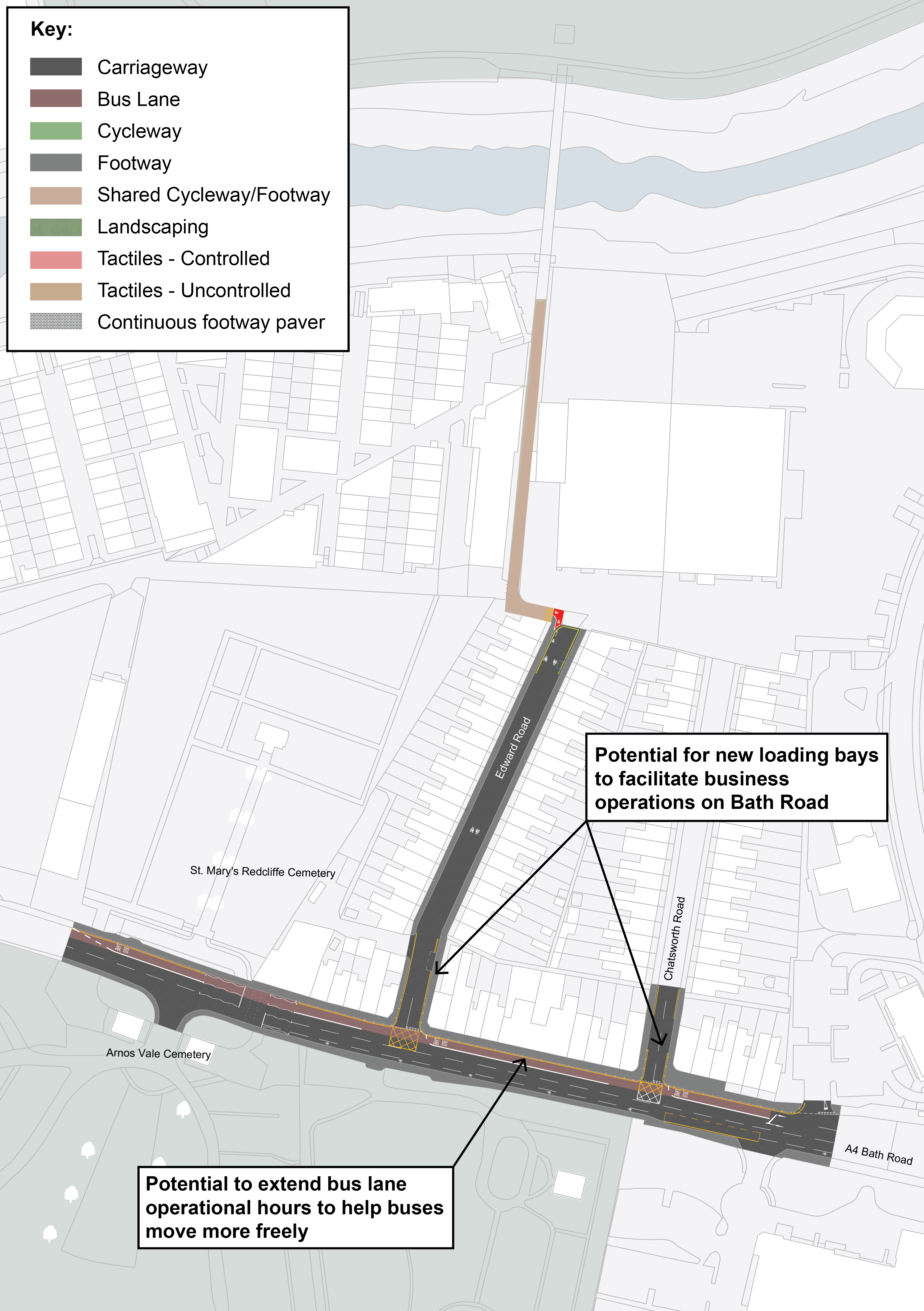
Changes to A4 Bath-bound bus lane times
Currently, buses are often caught in traffic at Arnos Vale at different times during the day causing delays. The Bath-bound bus lanes that run between Arnos Vale Cemetery and St Phillips Causeway between 4:30pm and 6:30pm Monday - Friday would benefit by operating for more hours of the day to help buses move more freely. We are consulting on what those additional hours of operation should be.
Loading and unloading would still be allowed outside of peak hours so that local businesses can keep running smoothly, and we’re looking to try and provide more loading bays on the section between Edward Road and Chatsworth Road section where there are currently double yellow lines.
Cameras would enforce fines for other vehicles (such as cars and lorries) that enter the bus lane.
Click image to enlarge
What would this mean?
- Longer operating hours for bus lanes would mean parking wouldn’t be allowed in the bus lanes during those hours
- Buses wouldn’t get stuck in traffic with other cars, and would be able to pull out of bus stops without waiting for gaps in the traffic
- Quicker bus journey times and improved reliability of buses
- Cyclists could also use the bus lane, with the extra space making it safer and easier to travel
What’s changed since 2023?
- In the last proposals, loading was not going to be allowed. We recognise this is important for local businesses, so we propose to allow loading and unloading outside of peak hours.
River Avon cycling, walking and safety improvements
To make the connection to the River Avon Trail from Arnos Vale easier and safer we are proposing to improve signposts, add new cycling road markings on Edward Road, and install lights and temporary CCTV to the cycle path between Paintworks and City Motors.
We would also add cycle storage for the residents of Edward Road and Chatsworth Road.
We are looking into the possibility of carrying out some of this work while the Sparke Evans Park Bridge is already closed to minimise disruption.
Click here to view the interactive map
What would this mean?
- New double yellow road markings on Edward Road would stop vehicles from blocking the route to Sparke Evans Park Bridge
- New signposts would direct cyclists along the route
- Secure and easily accessible cycle storage for Edward Road and Chatsworth Road residents with limited front garden space
- New cycle storage would mean there would be one less space that could be used for car parking on Edward Road, and possibly the same for Chatsworth Road, but this would allow for 6 cycle parking spaces per one car parking space
- Safer route for pedestrians and cyclists, especially in the evenings and winter
What’s changed since 2023?
- More detail is now available on the proposals
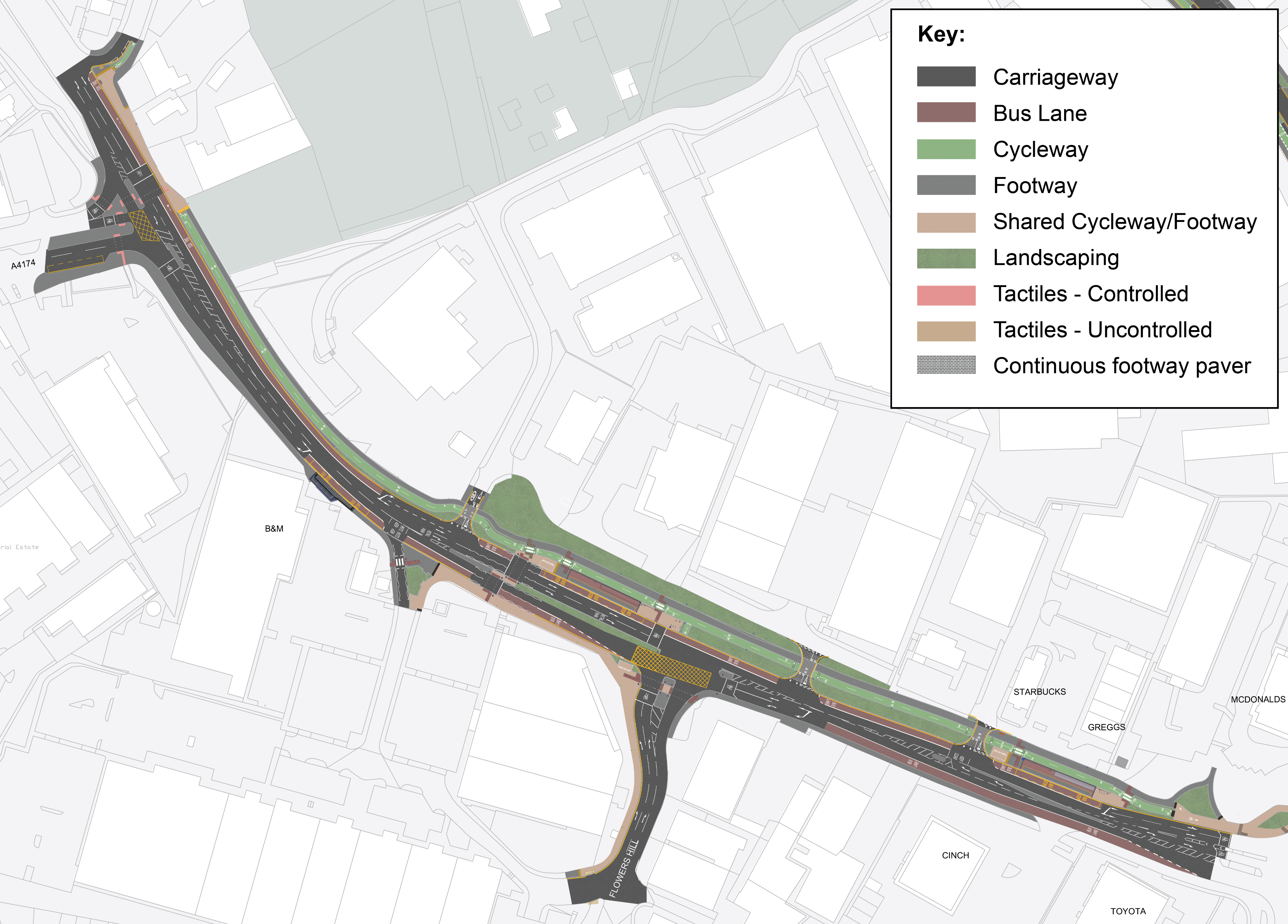
Bus lanes, cycle paths and shared paths
There are currently bus lanes running between West Town Lane junction and Flowers Hill junction in both directions. We are proposing to add a new eastbound bus lane from Flowers Hill junction to the Emery Road junction which will make the bus lanes almost continuous through this section.
We are also proposing changes to make it safer and easier for pedestrians and cyclists. There would be a two-way cycle path separate from the road, and a separate pedestrian pavement running from Bains Fireplaces to the corner of Emery Road by McDonald’s. Some of the grass verge and retail park parking on the north of the A4 would be used to create space for this. Space for a shared path would be created by removing the maintenance bay near the junction of Glenarm Road. We hope to connect this cycle path further into Bristol city centre as part of the longer-term proposals in the future.
The side road crossings on the northern side of the A4 would be a raised pedestrian crossing (built up to pavement level) to give priority to pedestrians and cyclists.
At the corner of the A4 and Emery Road by McDonald’s, the pavement would be made wider to provide more space.
Click image to enlarge
What would this mean?
- Buses would be less delayed and more reliable
- Quicker, easier, and safer routes for cyclists because they would be separated from traffic and won’t have to wait at traffic lights
- Fewer cyclists on the road could mean less congestion
- Safer and more pleasant route for pedestrians because the path would be set away from the road
- Easier and safer travel and more space for pedestrians, improved crossings, and slower traffic on side road junctions
What’s changed since 2023?
- New crossings across the A4 to connect both sides
There would be a new Toucan crossing (for pedestrians and cyclists) between Brislington Retail Park and the businesses on the other side of the A4 (such as Subway, Starbucks, and McDonald’s), improving access for people travelling by bus in either direction. This crossing would have a central island, and people would cross in two stages to help keep traffic flowing smoothly.
One of the entrances into Brislington Retail Park (next to TK Maxx and Subway) would be closed, but the exit lane would stay open. This means the extra space could be used for bikes, e-bikes, and e-scooter parking. The existing Bristol-bound bus stop would be upgraded and made bigger.
The other entrance into the retail park on Flowers Hill would remain open. The left-hand slip road on Flowers Hill would be closed to provide more space for pedestrians and cyclists and improve the crossing on Flowers Hill. This would tie in with the link for cyclists and pedestrians being created as part of a new residential development to the south of the retail park, which links cyclists on Flowers Hill with Hungerford Road.
Click here to view the interactive map
What would this mean?
- An easier experience for people visiting Brislington Retail Park via bus through a safe crossing between both sides of the A4 and bigger, more comfortable bus stop towards Bristol
- Easier and safer journeys by bike and e-scooter / e-bike to and from the retail park
What’s changed since 2023?
- More detail is now available on the proposals
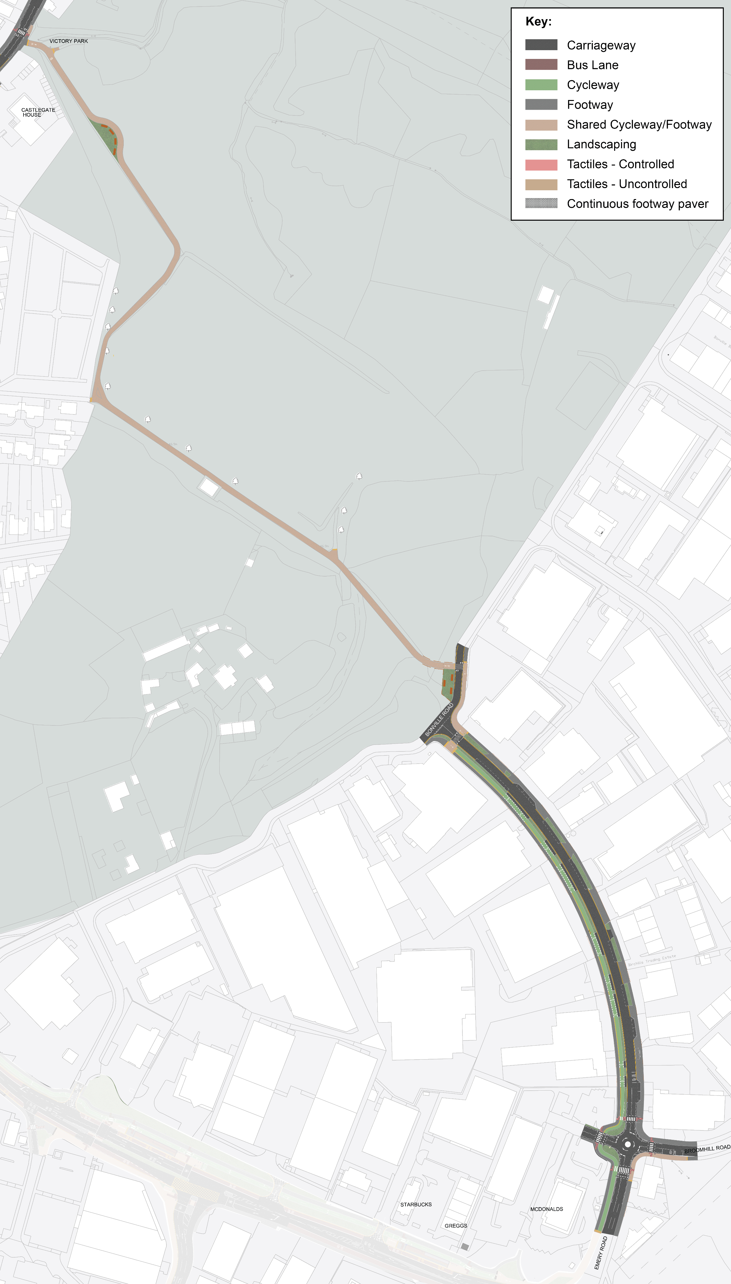
This is a key route for people who live in Sandy Park, Wick Road and the surrounding areas to reach St Brendan’s College and Oasis Academy. The proposals would make it far safer for students and schoolchildren to walk and cycle. We are proposing a new cycle path on one side of the road from Bonville Road along Emery Road to the junction of the A4 on the corner with McDonald’s. This would be separate from the pavement.
Lots of vehicles park on the pavement along Emery Road which can block access for pedestrians and interrupt traffic. Trees would be planted on both sides of the road to make the area more attractive, help the environment and discourage pavement parking. New marked parking spaces and loading bays would be created on Emery Road.
The new places for loading and parking and the new trees on Emery Road will mean there will be less space on the road to park for around 35 cars, but this would make it safer for pedestrians and cyclists especially children and young people on their route to St Brendan’s and Oasis Academy.
The speed limit would be reduced from 30 mph to 20 mph on parts of Emery Road and Broomhill Road.
There would be new zebra crossings on all sides of the mini roundabout by McDonald’s, St Brendan’s, and Broomhill Road to make it easier to cross safely.
There would be a new raised pedestrian crossings across Emery Road built up to the same height as the pavement just before the junction with Bonville Road. There would be another raised crossing across Bonville Road to link the corner of the junction with the entrance to Victory Park.
The path through Victory Park would be resurfaced and made wider so that it can be used by both pedestrians and cyclists, coming out on School Road. Lighting and temporary CCTV would be installed along the route through the park. There will also be a new path for cyclists and pedestrians that will connect Victory Park all the way to Bonville Road / Emery Road.
Click image to enlarge
What would this mean?
- Safer routes for students living in north Brislington to get to Oasis Academy and St Brendan’s College
- Quieter and safer route for pedestrians and cyclists to connect to the wider Brislington area, especially in the industrial area around Emery Road where cyclists would be separated from traffic and pedestrians
- Less pavement parking would mean better, safer routes for pedestrians
- Safer and easier crossings and a more usable route through Victory Park in the darker months
- Slightly longer journey times for drivers because of more crossings and reduced speed limit
- Some car parking at McDonald’s may need to be reconfigured
What’s changed since 2023?
- The cycle path has moved to the other side of Emery Road
- New zebra crossings on the mini roundabout
- Reduced speed limits in certain roads
- Changes to parking arrangements
- More detailed proposals are available
Please note: we are not consulting on proposals for this section of the A4 between the junction of the A4 with Emery Road and Stockwood Road and Hicks Gate roundabout as part of this consultation.
This part of the project, which could include extended bus lanes and a new cycle path is more complex because of engineering and environmental issues. It’s also linked to the Keynsham bypass, which has its own proposals under review.
Because of these challenges, we’re taking more time to work on the design, and any proposals taken forwards will have a separate consultation at a later date.